Yes I’ve just reckoned the 52 figure thanks. As to which parts of my property is liable to or not liable to property tax I’ll have to find out.
All your property is liable to tax. But the rate will be different for the different categories.
Look at the top of the columns to see the units that each figure relates to.
‘J’ is for gardens, ‘S’ is for sols (general ground surface?), ‘AG’ is for recreational land, a garden? Don’t know what ‘K’ stands for.
It’s confusing because of the figure 52. The ground floor area of my house is exactly 52 sq.m!
1 Like
AG is more likely agricultural.
2 Likes
The codes and designations given to me in this cadastre affair show AG as ‘terrains d’agrément’ - ‘garden or amenity land attached to a property, used for enjoyment rather than farming’?
1 Like
You’re lucky to get the surveyors to actually turn up and do some work.
As I was buying the small parcel of forest next to mine last year I arranged with them to arrive on the day I got out of hospital, late in June. I paid them €440 as a deposit of the €1,200 total fee and they turned up on time.
They had a quick look round and decided they couldn’t do the job as it had been done before and they would have to apply for the previous results.
They said it wouldn’t be long.
No more has been heard or seen of them since, No mention of my deposit or their further bill, just silence.
I had agreed with the Maire the actual boundaries and had my fencing erected accordingly , so I thought sod it, not bothered if they never come back. I am lucky that 3 boundaries are obvious and agreed, and the last one is an ancient sunken chemin rurale, so it was easy to do.
What is it about these people which makes them such numpties? Years ago we engaged the same office for a similar task and accepted the quote of 300 Francs? The current lot’s predecessor did the job but never sent the bill. A year later I enquired at the office and offered to pay. Was told no, not now, wait for the invoice. 25 years later I am still waiting.  I mentioned this to the present lot and we all had a good laugh.
Have a look on the geoportal. My experience of having purchase the next property is that it is not worth trying. Previously it was the forge and owned by my house but separate parcels.
I own 37 parcels including the forest included in the house purchase.
Well, I can only applaud my commune (maybe the department) for carrying out the mammoth task of unravelling those parcels of land, of which there are many, that have no physical seeable boundaries, except on a map that can’t be scaled.
A very large agricultural field is made up of multiple narrow numbered parcels of land. Like the fields shown here 30 years ago, not far from where I live.
But I think the commune cadastre géomètres will be concentrating on building property related surveys.
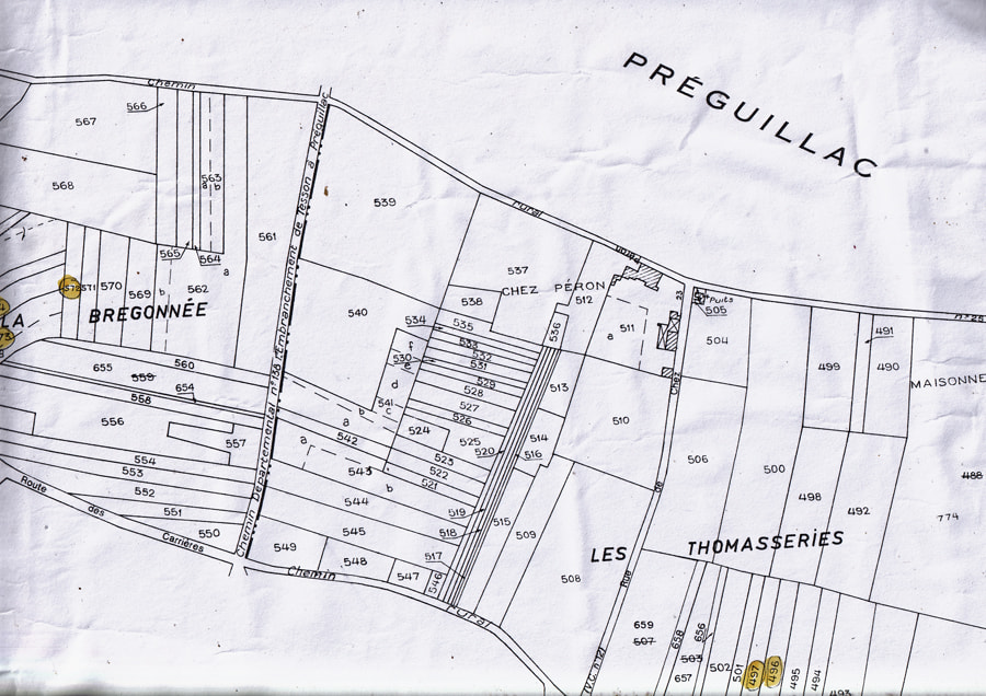
Yes, from what I was informed it is not possible to join parcels that designated, for instance urban and agricultural, only like parcels.
Interesting I looked up our house on the cadastral website and our house is fine but about four or five years ago they moved the road in front of our house. Our barn created a dangerous corner and the department created a new road taking a parcel of land from the farmer opposites field. The parcel of land taken for the new road shows up as a seperate parcel but the old road is not designated.
We had a meeting with the department representative, the commune representative and all the property owners of the effected land ( the Mairie was not represented by the Maire as it was his field that lost the most land. We were given the old road and an embankment was made to the new road we were told our property now extended to our side top of the embankment .
The surveyor measured out the land and put in yellow Bournes to mark the new corners. We were told they would send us the new cadastral but nothing has yet arrived. Talking to the farmers further up the road who also gained an old road ( and lost a bit of field) two years before us and they still do not have the new cadastral.
Oh yes and we were not charged anything and they volunteered to take up the old road but as it led to our barn where we keep our camper we asked them to leave two thirds of the tarmac.
It may well be online.
I think they just take a very long time the parcel for the new road is shown
If you think about how many properties and the lack of people to do the work, it does take a long time. I especially asked the expert doing all the measuring if he would send me printed out copies as I wanted to have them handy and he put me on a list with others who had no printer or PC to send them out to and he kept his word.
I have two doors from the street: #16 & #18. Impots has asked me to tell them what buildings are at #18. The details that they have a.t.mo are for #16.
As far as I can tell from the chart in the deeds created for the purchase of the property, which includes the house, the ‘summer house’ and the atelier, all are on one plot, outlined in blue.
The house is in 210. The summer house and atelier are faintly visible in 15. At the position on the plan of the #16 street doorway, it can be seen at bottom right.
At the position of the #18 doorway is a -. This would seem to indicate it is no longer extant for admin purposes. There is no mention anywhere in the deeds of the existence of #18 as a plot.
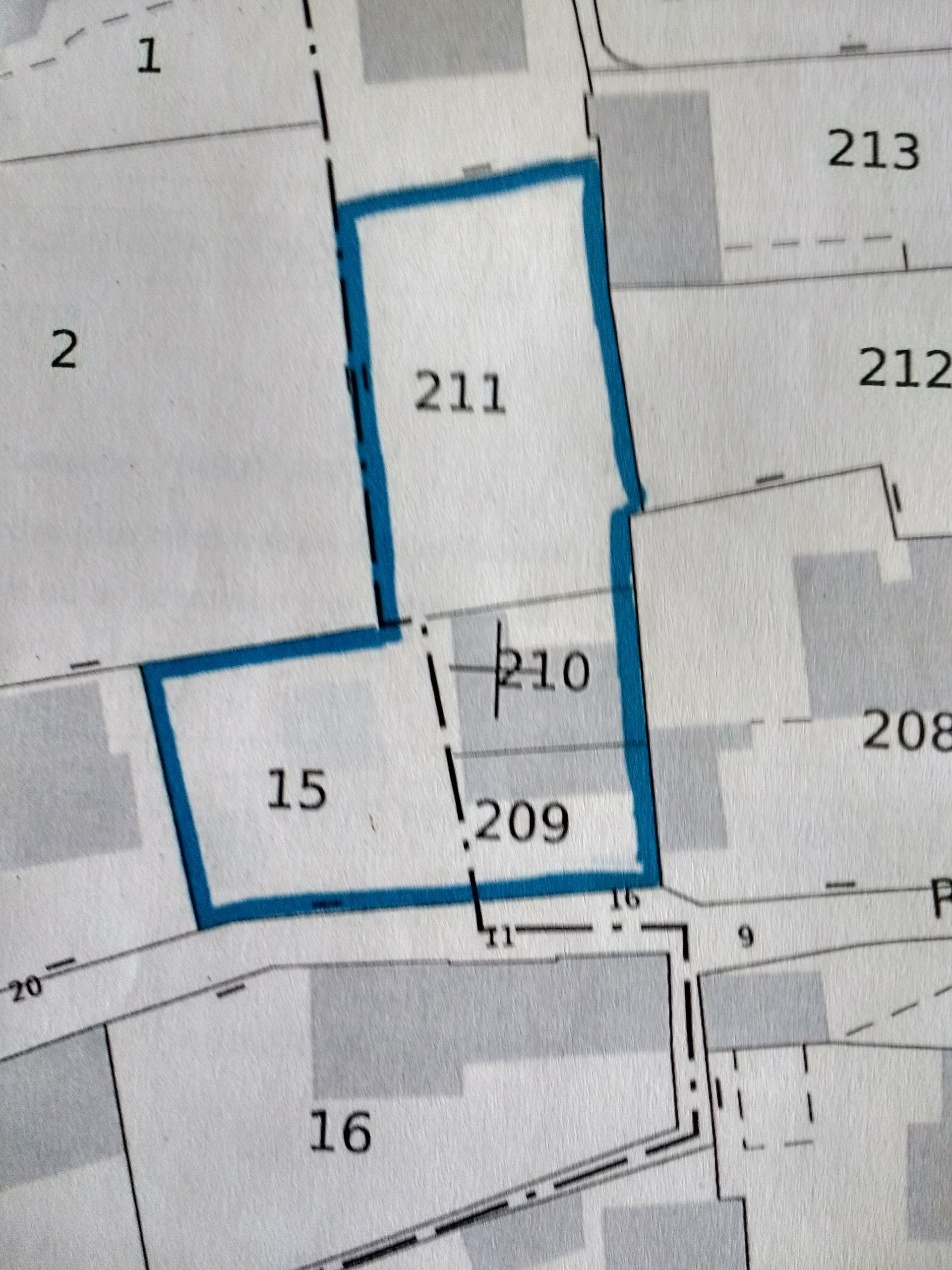
I don’t know what this represents but that all the ‘Numeros’ fall within the blue boundary.
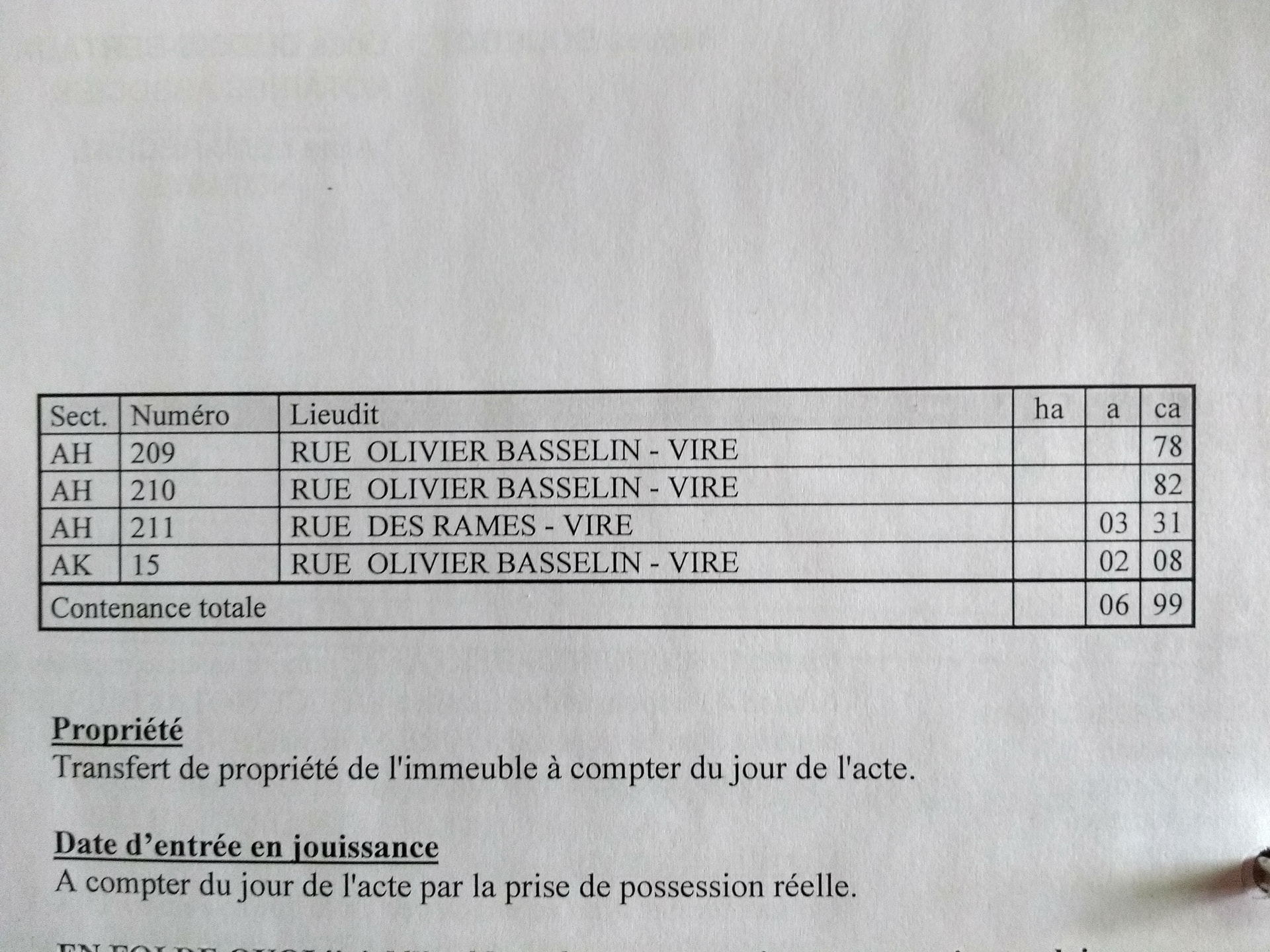
It seems to me that in 1958 two plots were bought, amalgamated into one and the buildings erected as indicated.
D’you think that’s correct? Is there something I’ve missed ?
Frankly, I would go and ask for help at my Mairie. They might well be able to unravel what’s what.
If things are really odd/difficult to understand, the Mairie can always get the “official bod” to come and take a look at your premises.
That happened to me and was sorted very easily and in friendly fashion. 
1 Like